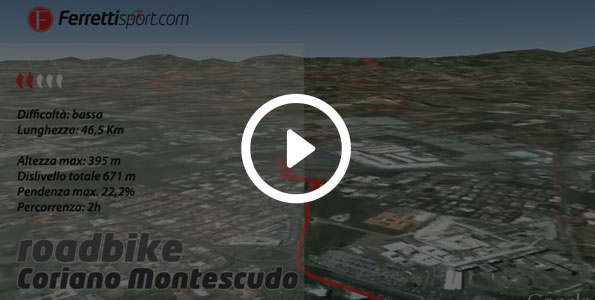
Coriano - Montescudo
Type : Road Bike
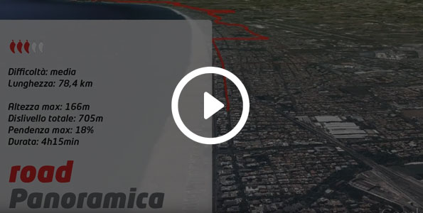
Itinerary info
Technical data
Length
46,5 Km
Maximum height
395 m
Total difference in altitude
671 m
Duration
2h
Maximum incline
22,2 %
Assessment
Track Rank
Fun
Landscape
Condition
Technique
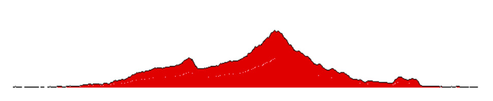
This route, which is 46.5 km in length and features a difference in altitude of 671 metres, can be used as a cool down route between two days of intense training, because the ascents are not particularly long or demanding.
It begins at Hotel Ferretti; exit the city and cycle behind the Le Befane shopping centre in the direction of Via Coriano. Take Via Coriano, which is long and generally not too congested (there's only one traffic light), and keep going until you reach the town of Coriano. This stretch is perfect for cycling at a brisk pace, even on the ascent which isn't too steep; after two roundabouts, you'll be in the small town of Coriano (the birthtown of Marco Simoncelli - MotoGP pilot).
After a stretch of cobblestones, exit the town: a fun succession of ascents and descents awaits you until you reach the top of the hill where the houses of the Croce hamlet are located.
Details of the Croce ascent 205 m a.s.l.
Total difference in altitude: 190 metres in 5.5 Km. Average incline: 3.8% Max incline: 10% Ascent time: 14 mins
At the umpteenth roundabout, which you go down to the left - the only dangerous part of the entire route because it's very steep - you may easily reach a speed of 70 km/h. The road ends at the bottom of the Conca river valley and, on the opposite side of the valley, you can admire the splendid fortress of Montefiore Conca.
Take the road towards the mountain; this route gently heads up towards splendid Montescudo, another Malatesta fortress, which acts as a terrace looking out onto the valley, offering one of the most scenic views of the area. The ascent is approximately 4.5 km. The only demanding section is in the last couple of hundred metres of the final stretch.
Details of the Montescudo ascent 395 m a.s.l.
Total difference in altitude: 350 metres in 5.7 Km. Average incline: 7.2 % Max incline: 22.5 % Ascent time: 20 mins
At the top of the hill, at the foot of Montescudo, you can catch your breath and replenish your water at the waterfountain located near the petrol station.
When you hop back on the saddle, continue towards Trarivi until reaching Ospedaletto: a very entertaining and well-paved downhill scenic route awaits you. This road is wide enough for you to go down safely as you continue towards Rimini.
The final sacrifice is required in the Gaiofana area: take the ascent to the right with a 14% incline - it's very demanding, even if quite short; this will take you to San Lorenzo in Coreggiano.
At the top of the hill on the left, there's a secondary road which traverses lush green hills, flanked by secular trees; you'll go past Villa Des Verges (a splendid historic neoclassical residence), which offers you a scenic view of part of Rimini.
At the fork in the road, head back towards Rimini to complete the trail and return to the hotel for some well-deserved R&R.