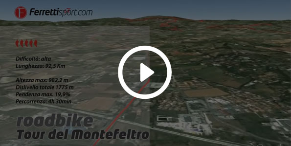
Tour of Montefeltro
Type : Road Bike
Itinerary info
Technical data
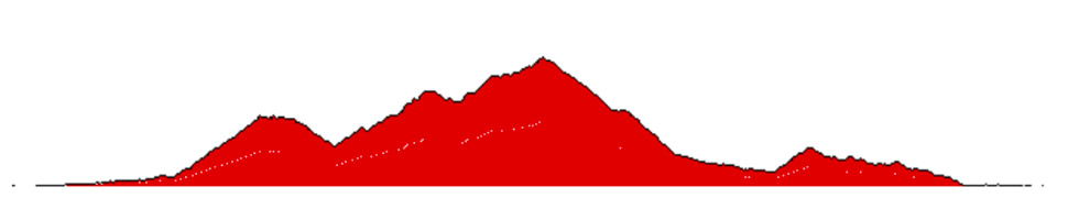
Length
92,5 Km
Maximum height
982,2 m
Total difference in altitude
1775 m
Duration
4h 30m
Maximum incline
19,9 %
Assessment
Track Rank
Fun
Landscape
Condition
Technique
This route is quite demanding and is approximately 95 km long. We therefore recommend having enough water bottles and vitamin supplements to get you through this 4-to-5 hour-long excursion.
You depart from Hotel Ferretti in the direction of San Marino, taking the statale (the main state road) for approximately 13 km on a flat surface until reaching Dogana di San Marino, the state border with the Republic of San Marino. From here, it's 9 km of uninterrupted uphill cycling, until you reach 600 metres above sea level at a big roundabout where the dual carriageway ends – this is an excellent spot for scenic views of the entire Republic of San Marino and Rimini province.
Details of the San Marino ascent (Borgo Maggiore) 595 m a.s.l.
Total difference in altitude: 565 metres in 7.96 Km. Average incline: 7.1% Max incline: 26.2% Ascent time: 33 mins
Turn left towards Chiesa Nuova / San Leo, going past the foot of Mount Titan where the San Marino castles are located. Then there’s an ascent which is not too long, but is very demanding.
Once reaching the top of the hill, follow the directions for the "la Cegna" farmhouse, paying attention to some of the bumpy sections in the road to avoid punctures or damage to your bicycle.
The ascent it quite tough and, before reaching the farmhouse, there are some very challenging stretches, even if the view of San Marino and Valmarecchia will make you forget the struggle. The section after the farmhouse which takes you to Villagrande is the toughest and it takes us up to 950 metres above sea level. This is 10km is almost entirely uphill with the exception of small flat stretches where you can catch a breath, flanked by meadows designed for cows to graze on.
Details of the Villagrande ascent 1001 m a.s.l.
Total difference in altitude of the two sprints: 1044 metres in 18.3 Km. Average incline: 6.7% Max incline: 21.3% Ascent time: 1h20 mins
At 1 km from the summit, you can replenish your water bottles from a fresh source; once you reach the top, you'll need to cover up, because an 18 km descent awaits you. This will lead you across Pugliano and to the foot of the marvellous and unique fortress of San Leo, until you reach the main state road (statale) known as "La Marecchiese". The descent isn't too technical, but you need to pay a lot of attention, because the road is not well-paved in some stretches.
If you want to add one more scenic treat to your journey back to the hotel, at the crossroads, head in the direction of Verucchio: another Malatesta fortress awaits you only 3 km away with a perfectly-paved uphill ascent. Once again here, at the top, in the centre of the town, you can stock up on water at the water fountain. The way back is almost entirely downhill and traverses Cantelli, then continues along the watershed which offers a beautiful view of the sea as far as Covignano; at Covignano, head downhill and back into Rimini.
Details of the Verucchio ascent 296 m a.s.l.
Total difference in altitude: 217 metres in 3.2 Km. Average incline: 7% Max incline: 13.5% Ascent time: 12 mins